 17th December 2020
While we take for granted that our mobile phone is installed with Global Positioning System (GPS) technology that can accurately pinpoint the device’s location to within a few metres, there is a long and storied history behind the concept.
Today, the world of shipping benefits enormously from the invention, that enables tracking and positioning for thousands of ocean-going vessels every day.
The modern-day GPS was launched in 1973 by the US Department of Defense to help support accurate navigation and to determine the location of military aircraft, vessels and other vehicles in the air, at sea and on land.
However, the history of accurate geographical positioning has its roots in China, more than 2000 years ago, during the Han Dynasty with the invention of the magnetic compass.
The other major development that more accurately helped seafarers establish their ship’s position was the sextant, invented in Iran by Abu-Mahmud al-Khujandi in 994AD. In 1731 the early version of the modern maritime sextant was invented by British mathematician John Hadley; the instrument was then referred to as an octant. Fine-tuned by British inventor John Bird some 26 year later, the sextant was used first by the Royal Navy and commercial ships.
The sextant is a tool for navigation, using the stars or planets and measures the angle between the horizon and a visible object.
The combination of the compass and sextant provided mariners with more accurate navigational tools. Because the compass needle always points north position it was possible for seafarers to know where they were and in which direction their boat or ship was heading. This combination provided the blueprint for modern day positioning systems.
GPS uses satellites and is a radio-navigation system that provides very accurate data regarding geo-location and time information to any GPS receiver located on Earth. The system is developed, operated and maintained by the US and is free to any user with a GPS receiver.
Now GPS is used in transportation, civil works, policing, personal navigation, outdoor sports, robotics and military applications.
One of the benefits of GPS is that the user does not need to send any data and the communication is one directional. Another advantage of GPS is that it does not require any telephone or internet connection for the data reception, according to Electronics Infoline.
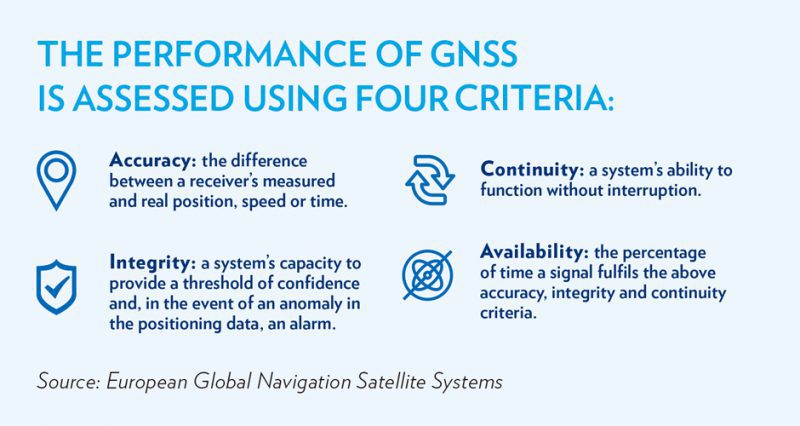
GPS is part of a constellation of the satellites that comprise the Global Navigation Satellite System (GNSS) providing signals from space that transmit positioning and timing data to GNSS receivers.
GNSS includes Europe’s Galileo, the USA’s NAVSTAR Global Positioning System (GPS), Russia’s Global’naya Navigatsionnaya Sputnikovaya Sistema (GLONASS) and China’s BeiDou Navigation Satellite System (BDS).
Earlier this year China successfully launched the final satellite in its BeiDou-3 navigation system, comprising 35 satellites and provides global navigation coverage.
The third version of the BDS offers an alternative to Russia’s GLONASS and the European Galileo systems, as well as America’s GPS.
Future plans promise to support a more accessible and integrated system scheduled to come online by 2035 with BDS at its core.

There are incredible benefits that GPS and other satellite navigation systems provide to the shipping industry, such as safety at sea by pinpointing vessel locations during an accident or airlifting a sick seafarer from the ship.
Other benefits mean that master of a ship can optimise his route planning in real time using the accuracy of the positioning technology, reducing emissions from the vessel and fuel costs.
As coverage of satellite positioning grows and accuracy improves, there will be enhanced benefits for shipping in the years ahead.
Tele-remote-controlled equipment coupled with automated equipment defines a port’s competitive advantage in its ability to optimise performance by improving its efficiency and flexibility. The equipment and assets required to perform this task constitutes about 75 percent of the total costs of a port.
Despite the ability of GPS to pin-point the exact location of vessels, equipment and vehicles, current port and logistics systems have limits on how much data and information sharing they are capable of, using current technology, according to Marglory, a Morocco-based logistics services provider.
The main advantages of 5G is the density of the data, transfer speeds and latency. 5G can support one million sensor devices in a square kilometre as opposed to 100,000 devices that 4G can reach.
Similar to GPS, 5G is connected to satellites via base stations which enables communication between ship and shore and is enabling ports to develop ‘Smart’ operations.
The development of 5G enables access to granular data and information as well as a transparent view of cargo transiting either by sea or land. It can also enhance situational awareness and site security enabling broader coverage for video cameras without expensive cabling infrastructure and allows workers to be equipped with wearable sensors for remote health and fatigue monitoring.
Machine and sensor data can be combined with analytics to create virtual models or ‘digital twins’ of equipment in order to assess equipment performance, optimise new workflows before they are implemented. This technology will reduce the risk of equipment malfunctions and breakdowns, enabling precise timely preventative maintenance and added flexibility to try new models and flows for performance improvement. To compare, GPS can provide the exact location of a container, while 5G can expedite the flow of big data and communication signals.
In short 5G helps to improve the flow of data throughout the supply chain and has the added benefit of helping to verify responsibility for the cargo and its ownership, this can help when cargo is moving from one mode of transport to another.
“The southern Chinese port of Guangzhou is promoting intelligent port development with several key industry players in the Greater Bay Area. The project will develop the Guangdong-Hong Kong-Macao Greater Bay Area’s first full automated terminal with 5G application and utilising the BDS-3.”